Medieval Maps and Modern Fantastical Utilizations by Jax Young
Hand Me the Map!
To describe a map as merely a tool for navigation would be a gross oversimplification. Long before maps were used to provide precise directions, they served to guide people through the perceived dangers and uncertainties of the world. Many modern science fiction, adventure, and fantasy series draw their mythologies and world-building from these early forms of mapping. Two medieval map types that have had a particularly strong influence on contemporary media are the T-O map and the moral map.
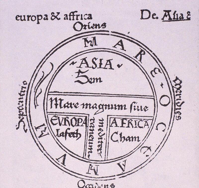
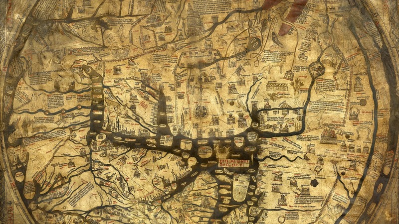
T–O maps derive their name from their distinctive design: a “T” enclosed within an “O” (fig. 1). These maps depict the world as consisting of three continents—Asia, Europe, and Africa—divided by bodies of water and encircled by a surrounding ocean. Rather than striving for geographical accuracy, T–O maps emphasize a Christian worldview and the spiritual organization of space. Heaven is typically placed at the top, hell at the bottom, with holy lands at the center and monstrous or unknown creatures inhabiting the margins. Regions beyond known boundaries were often portrayed as dangerous and inhospitable. One of the most well-known surviving examples is the Hereford Mappa Mundi (Mappa Mundi meaning, map of the world), created around 1300 CE (fig. 2). At first glance, a Mappa Mundi may appear disorienting, as its layout defies modern expectations of geography. The Hereford map was not intended as a precise navigational tool but as a representation of the Christian world and its inhabitants. Such maps were used to illustrate pilgrimage routes and sites of cultural and religious significance, with Jerusalem positioned at the center of the “world.”
In recent years, scholars have begun to reassess how medieval maps are interpreted, as well as how we understand the perspectives of their creators. The notion that medieval mapmakers were ignorant of the broader geographical world is increasingly recognized as a misconception. In his article “Reality, Symbolism, Time, and Space in Medieval World Maps,” David Woodward argues that:
The mappa mundi carry levels of meaning that have been completely misunderstood. In the nineteenth century, when systematic studies of these maps first appeared, they were interpreted in light of the view that maps (to be true maps) were intended to show geographical reality structured according to a coordinate system, such as longitude and latitude. These nineteenth century writers also oversimplified and underestimated medieval thinkers' understanding of the physical world; this is reflected in the frequently repeated views that most medieval scholars thought the earth was flat or that Jerusalem should be shown at its center. Some of these misunderstandings arose from a tendency to regard the culture of the Middle Ages as essentially static (Woodward 1985: 510).
The monstrous beings depicted at the fringes of medieval maps were often associated with Gog and Magog, representing a symbolic division between “us” and “them.” As Krezla and Mlinari explain in Visual Images on Medieval and Early Modern World Maps: Iconography of the Known and the Unknown, these figures were imagined as inhabiting “cities, located on the edge of the known world, a place out of the reach of civilization, where savages dwell” (2022: 30). Such terrifying imagery served as a moral and existential warning against straying from the familiar path—suggesting that venturing too far into the unknown could lead to destruction.
Some of these creatures were based on real animals, such as lynxes or elephants, though they were often endowed with exaggerated or fantastical traits. Others were entirely mythical, populating the margins of maps with danger: dragons, basilisks, troglodytes, sea serpents, sciapods, unicorns, and blemmyes. When examined through a modern lens, many of these depictions reveal a blend of observation, misinterpretation, and imaginative embellishment, blurring the line between reality and myth. These creatures were not confined to maps alone; medieval manuscripts also featured rich collections of such beings, presenting them as part of a broader attempt to catalogue the known and unknown world. The concept of monstrous entities inhabiting the periphery has endured as a powerful narrative device, continuing into modern fantasy and science fiction literature, film, and television. In these stories, beasts often function as trials for heroes, testing their strength, faith, or moral resolve.
One enduring example is the basilisk, though its depiction varies widely across narratives. In the Harry Potter series, the basilisk appears as a giant serpent capable of killing with its gaze and venom. In The Witcher, it takes on a more avian form, with wings, talons, and a petrifying breath. While these interpretations differ, both draw loosely from earlier traditions that connect the creature to dragon-like origins. Notably, the basilisk predates medieval mapmaking, appearing as early as Pliny the Elder’s Naturalis Historia (ca. 77 CE).
Other figures, such as troglodytes, were imagined as cannibalistic “others,” sometimes said to have been confined by Alexander the Great to the far edges of the world. They were frequently depicted as cave-dwellers who consumed human flesh, reinforcing the idea that beyond the borders of civilization lay chaos and savagery. These marginal figures served a clear purpose: to signal that no one should venture further.
The trope of dangerous, isolated peoples persists in modern storytelling. Narratives often feature remote or erased locations—places absent from maps—inhabited by those living outside the bounds of “civilized” society. Films such as The Hills Have Eyes, Wrong Turn, and The Texas Chainsaw Massacre echo this theme, portraying isolated communities as violent and cannibalistic. Like their medieval predecessors, these stories act as cautionary tales, warning that to stray from known paths is to risk encountering death—or something far worse.
When we turn our attention to moral maps, we see a shift away from fantastical beasts toward the stereotyping of entire regions based on the compass. In these representations, the north is depicted as cold and inhospitable, the south as a harsh desert inhabited by dangerous peoples, the east as the domain of evil—populated by barbarians and savages who threaten the Christian world—and the west as the center of goodness, culture, faith, and civilization. From this framework, it becomes fairly clear who was creating these maps and how their worldview shaped geographic interpretation.
The influence of such moral mapping persists in modern storytelling and world-building. Works like The Lord of the Rings, Star Wars, and Game of Thrones all draw on this spatial logic. In these narratives, the north is often a frozen, unforgiving landscape; the east is home to hostile, warlike societies; the south is a hot, barren wasteland; and the west represents the heart of civilization and the domain of the protagonists. These patterns reflect a continuation of medieval mapping traditions, adapted into contemporary forms of storytelling.
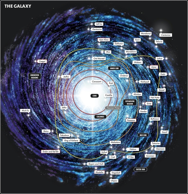
Using Star Wars as an example, the structure of the galaxy mirrors the principles of moral maps. The Core—positioned at the center—represents the height of civilization, with technologically advanced planets and relative stability. As one moves outward, the environments become more hostile and the inhabitants more unfamiliar or “othered,” culminating in the Outer Rim, where harsh desert and frozen worlds dominate. Though presented through the lens of science fiction, this spatial hierarchy echoes medieval conceptions of order and danger.
Modern science fiction also expands upon mapping through technological visualization. Unlike medieval maps, which were static, contemporary depictions can be projected, animated, and zoomed in for greater detail. However, elements of interactivity are not entirely new. As Daniel Connolly explains in “Imagined Pilgrimage in the Itinerary Maps of Matthew Paris,” the maps created around 1250 at the Benedictine abbey of St. Albans already engaged viewers in dynamic ways:
Turning the itinerary pages leads the viewer toward Jerusalem, and folding or unfolding the flaps… transforms the route and adds to the meanings of those spaces… This interactive quality has been completely overlooked by modern scholarship (1999: 610).
These maps invited users to engage physically and intellectually, guiding them through imagined pilgrimages while reshaping their understanding of space. In this sense, they functioned as a medieval precursor to modern “zooming” or “enhancing,” offering increasingly detailed and immersive experiences as viewers followed sacred routes.
Ultimately, maps reveal as much about their creators as they do about the world they depict. Their design is shaped by cultural values, beliefs, and intentions, and their influence often extends far beyond their original context. In modern media, maps continue to guide audiences through narrative worlds, drawing on familiar tropes and spatial hierarchies that echo the past. The next time a map appears in a book, film, or television series, it is worth taking a closer look—you may be surprised by what it reveals.
Bibliography
Connolly, D. K. “Imagined Pilgrimage in the Itinerary Maps of Matthew Paris.” The Art Bulletin, vol. 81, no. 4, 1999, pp. 598–622. JSTOR, https://doi.org/10.2307/3051336. Accessed 8 Mar. 2026.
Krezla, P, and D. Mlinari. 2022. Visual Images of Medieval and Early Modern World Maps: Iconography of the Known and the Unknown. Kartografija i geoinformacije, 21.1: 26-55
Woodward, D. 1985. “Reality, Symbolism, Time, and Space in Medieval World Maps.” Annals of the Association of American Geographers, vol. 75.4: 510–21.